Log in
All resources
Create a design
9,296 Free Artworks of Map Collection
eran laor cartographic collection
bibliothèque nationale de france
latin-language maps
frans hogenberg
british library
joan blaeu
copper engraving print
beschreibung der städt der welt - braun & hogenberg - btv1b52512111k
french-language maps
maps from the mechanical curator collection
maps of vienna by braun & hogenberg
eran laor cartographic collection
maps of bourges by braun & hogenberg
eran laor cartographic collection
maps of heraklion by braun & hogenberg
eran laor cartographic collection
maps of conil by braun & hogenberg
eran laor cartographic collection
maps of prague by braun & hogenberg
eran laor cartographic collection
maps of lübeck by braun & hogenberg
eran laor cartographic collection
lawrence h. slaughter collection of english maps, charts, globes, books and atlases
pre-raphaelite brotherhood
maps of asia by jean-baptiste bourguignon d'anville
french-language maps
fire and sword in the sudan (1896) by slatin
maps from the mechanical curator collection
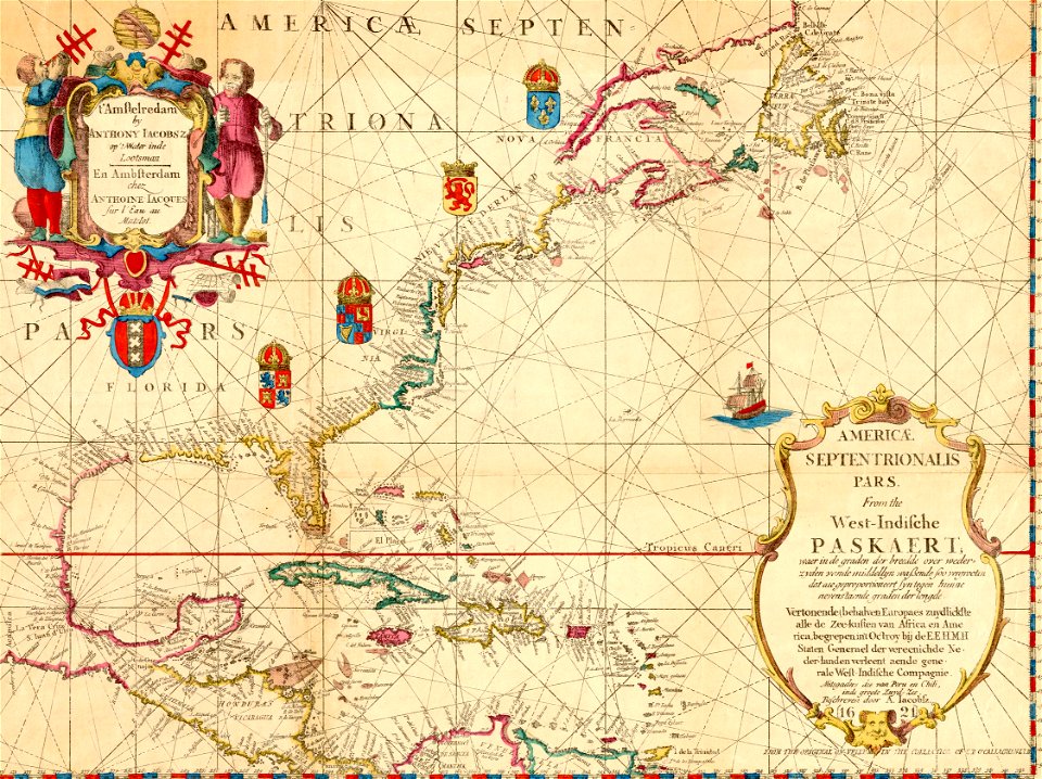
1620s maps of north america
1620s maps of the caribbean
liber qvartvs contrafactur vnd beschreibung von den vornembsten stten der welt (zzk 0.32)
patrimonium 2 (project)
juan de la cruz cano y olmedilla
1755 maps of north america
liber qvartvs contrafactur vnd beschreibung von den vornembsten stten der welt (zzk 0.32)
patrimonium 2 (project)
novus atlas sinensis
old maps of sichuan
17th-century maps of cumberland
old county maps of cumberland
maps of paris from bibliothèque nationale de france
proletarian literature
maps from the mechanical curator collection available to georeference
maps from the mechanical curator collection
peter schwingen
peter de weerth
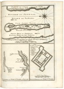
maps of the senegal river
1750 maps
victor levasseur - maps of the world
old maps of north america
maps from the mechanical curator collection available to georeference
maps from the mechanical curator collection
maps from the mechanical curator collection available to georeference
maps from the mechanical curator collection
dutch 18th-century paintings in the rijksmuseum amsterdam
august christian hauck
geneviève brossard de beaulieu
jean-françois de la pérouse
maps in the british museum
maps by thomas kitchin
maps of paris from bibliothèque nationale de france
maps of paris by braun & hogenberg
eran laor cartographic collection
pierre françois tardieu
eran laor cartographic collection
pierre mortier
map of italy by guillaume delisle (1700)
eran laor cartographic collection
maps of cusco by braun & hogenberg
eran laor cartographic collection
maps of mons (hainaut) by braun & hogenberg
eran laor cartographic collection
maps of konstanz by braun & hogenberg
eran laor cartographic collection
maps of lisbon by braun & hogenberg (1572)
eran laor cartographic collection
maps of spain by tomas lopez
1780 maps of spain
media contributed by university of illinois urbana-champaign university library
negroland
old maps of pyrénées-orientales
coats of arms of perpignan
map of bruges by marcus gheeraerts (i)
drawings in the groeningemuseum
maps from the mechanical curator collection
19th-century maps of the nile river
henricus hondius ii, nova totius terrarum orbis geographica ac hydrographica tabula, 1630
eran laor cartographic collection
1710s maps of eastern europe
1710s maps of the balkans
johannes honterus
renaissance
old county maps of oxfordshire
bodleian maps collection
eran laor cartographic collection
emanuel bowen
maps from university of amsterdam special collections
atlas der neederlanden
maps from university of amsterdam special collections
atlas der neederlanden
maps from university of amsterdam special collections
atlas der neederlanden
church towers in hamburg
jan diricks van campen
antoine-françois tardieu
maps from gallica
maps by pieter van der keere
maps by abraham ortelius
maps of paris from bibliothèque nationale de france
16th-century maps of paris
old maps of cities in asturias
1777 maps of spain
media from accademia delle scienze di torino
high renaissance
cornell: persuasive cartography: the pj mode collection
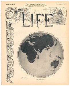
james montgomery flagg's life covers
print room of the university of antwerp
citadel van antwerpen
maps of canterbury by braun & hogenberg
william smith (herald and playwright)
eran laor cartographic collection
latin-language maps
victor levasseur - maps of france
19th-century maps of finistère
italian-language maps
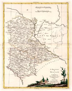
1781 maps of ukraine
history of whitby, north yorkshire
british library maps collections
portrait paintings by michele gordigiani
scapigliatura
maps from the mechanical curator collection
icelandic-language maps showing history
eran laor cartographic collection
willem blaeu
watercolor drawings by johannes vingboons
tobago
atlas maior, vol 5 (england) - joan blaeu, 1667 - bl 114.h(star).5
old county maps of montgomeryshire
atlas maior, vol 5 (england) - joan blaeu, 1667 - bl 114.h(star).5
old county maps of denbighshire
maps of paris from the david rumsey historical map collection
maps of paris by caspar merian
atlas maior, vol 5 (england) - joan blaeu, 1667 - bl 114.h(star).5
old county maps of bedfordshire
atlas maior, vol 5 (england) - joan blaeu, 1667 - bl 114.h(star).5
old county maps of worcestershire
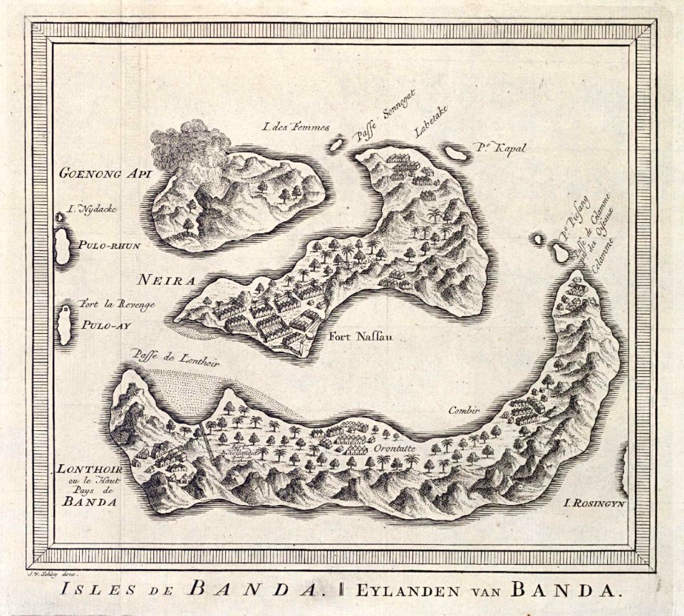
old maps of the dutch east india company - malaysia
maps of the dutch east india company - indonesia
maps of the dutch east india company - indonesia
1750s maps of indonesia
old maps of the dutch east india company
1750 maps
maps of the dutch east india company - indonesia
18th-century maps of sumatra
eran laor cartographic collection
pierre françois tardieu
eran laor cartographic collection
thomas kitchin
german-language maps from ios map collection
1910s maps of the balkans
vue (en relief et à vol d'oiseau) de paris by jacques-alphonse testard
maps of paris from bibliothèque nationale de france
eran laor cartographic collection
avraham leib monsohn
charts and maps of the royal museums greenwich
1777 maps of new york (state)
maps in the library of congress
1639 maps of the caribbean
carte de la mer mediterranée (1764) by roux
eran laor cartographic collection
beschreibung der städt der welt - braun & hogenberg - btv1b52512111k
maps of kleve by braun & hogenberg
maps from gallica
old maps of genoa
beschreibung der städt der welt - braun & hogenberg - btv1b52512111k
maps of hormuz by braun & hogenberg
beschreibung der städt der welt - braun & hogenberg - btv1b52512111k
maps of braunschweig by braun & hogenberg
beschreibung der städt der welt - braun & hogenberg - btv1b52512111k
maps of casablanca by braun & hogenberg
beschreibung der städt der welt - braun & hogenberg - btv1b52512111k
maps of neuss by braun & hogenberg
beschreibung der städt der welt - braun & hogenberg - btv1b52512111k
maps of valletta by braun & hogenberg
beschreibung der städt der welt - braun & hogenberg - btv1b52512111k
maps of parma by braun & hogenberg
turgot map of paris, david rumsey historical map collection – derivative files
hôtel du plessis-guénégaud
maps by emanuel bowen
1750s maps of germany
1858 van de velde maps of palestine and jerusalem
eran laor cartographic collection
atlas maior, vol 11 (asia) - joan blaeu, 1667 - bl 114.h(star).11
1667 maps
17th-century maps of bordeaux
17th-century maps of dordogne
old maps of charente-maritime
maps by nicolas sanson
atlas maior, vol 4 (netherlands) - joan blaeu, 1667 - bl 114.h(star).4
1667 maps
1660s maps of spain
1667 maps
17th-century maps of xaintonge
old maps of charente-maritime
maps from university of amsterdam special collections
atlas der neederlanden
maps from university of amsterdam special collections
atlas der neederlanden
maps from university of amsterdam special collections
atlas der neederlanden
901 - 1000 of 9,296
Next page
/ 93


![[Map of the islands of Hispaniola and Puerto Rico]., Johannes Vingboons, 1639](https://cdn.creazilla.com/illustrations/6627413/map-of-the-islands-of-hispaniola-and-puerto-rico-loc-2003623402-illustration-md.jpeg)